|
PRE-ADAMITE HISTORY. History, under a strict definition, should include nothing more than the record of human transactions, but I here venture to introduce an article which relates principally to natural science. The wells, springs, cisterns, and sewers; the general improvement of our streets; the protection of the lake shore and the state of our harbor, are all influenced by the geological structure beneath us. I imagine, also, that it will be interesting to look briefly at the cause of the most recent geological changes. On the gravelly plain which was selected by the surveyors in 1796 as the site of a future city , there are numerous low, sandy ridges, which are parallel to the shore of the lake. These ridges were the first roads of the pioneers on their way to the west. They appear to have been formed beneath the surface of the water at a remote period, when the lakes had a much higher level than now. On all sea coasts long, narrow sand-bars are known to form, a short distance from the shore and parallel with it. Their position is indicated to the navigator by the outer line of breakers. The formation upon which this city rests is geologically the most recent of all, except the alluvium. There are trees, sticks, and leaves imbedded in it, which have not yet perished; but in reference to the period of written history its era is very ancient. It was formed after the earth had assumed substantially its present surface, in a topographical sense. Geological investigations show conclusively, that since the era of the coal, the chalk formations, and even the tertiary beds, there was in the northern hemisphere, north of about 40�, a period of universal ice; as there is now in Greenland. As that frozen age was disappearing the more ancient and solid rocks of the Carboniferous, Devonian and Silurian ages, on which the universal glacier rested and moved; were ground down, scoured and polished. The crushed and pulverized materials of the rocks form what is commonly called earth, as distinguishable from indurated strata. In the northern hemisphere, the ice movement was toward the south, which carried the fragments of rocks and their mixed debris, in the form of dirt. Always towards the equator. In this way we have here pieces of rocks designated as "boulders" or lost rocks; which were originally in place on the shores of lake Superior or Hudson's Bay. Our soil is composed of the disintegrated particles of these rocks, mingled with the crushed portions or strata nearer home. The surface formation on which the city stands belongs to the close of the of the ice period when the glacial masses were disappearing, and the waters were assuming their present level over the land. It is sometimes called "post-tertiary," or "quaternary," but more often "northern drift." There are in it no rocky beds, although it is frequently stratified, and laminated. The waters from which, by a joint action with moving ice, it was transported and deposited, were throughout the upper lake country wholly fresh. Numerous shells have been found in it, all of which belong to fresh, and none to sea water. Nearer the ocean, the shells of the drift are of marine origin. Throughout all the region of the upper lakes, there are numberless trees, logs, sticks, branches and leaves scattered through the drift formation. It is composed of red, blue and dun colored clay, on which rests coarse sand, gravel and boulders. By an analysis of the laminated blue clay taken from the foot of Ontario street, made some years since it was found to contain:
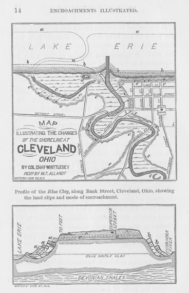
An analysis of the red laminate clay of lake Superior gave a similar result, except in regard to the red oxide of iron which exceeds that of the lake Erie clay, and which is the cause of its red color. The drift clays always contain alkalies, sometimes in sufficient quantities to prevent their being used for the purpose of making brick. Sometimes it changes to a compact hard-pan, composed of clay and fragments of rocks. There are boulders and pebbles of northern rocks throughout the whole mass. In many places it is not stratified, but mixed and confused like the moraines of Alpine glaciers now being formed. There are places in the valleys of the upper lakes where the drift is 600 and 800 feet thick, but here, it is probably nowhere more than 150 feet, down to the underlying rock. When lake Erie receded to its present level, its ancient bed was partly inclined like the rim of a basin sloping towards the water. The mouths of the rivers were farther out than now, the lake was smaller in size and its shore line quite different. Where the shore was composed of marly clays, as it is along much of its outline, the waves made rapid inroads upon it and the soft materials were dispersed by currents that exist in all bodies of water. There is a tradition that when the French first coasted along the south shore of lake Erie, the Indians remembered when there was no outlet at the present mouth of the Cuyahoga River. It discharged at the old mouth one mile west, and the point of the bluff extending westerly from the light house then interposed between the river and the lake. A mound, the remains of this point is represented in the sketch made by Capt. Gaylord in the year 1800. It remained at nearly the same height when I first saw it in 1827. Operating upon such material as the blue marly clay, the encroachments of the lake were rapid. On the Canada shore opposite Cleveland the formation is the same and its destruction equally rapid. The remains of soldiers who were buried near the crest of the bank in the war of 1812 were in 1836 found to be at the water's edge. As the lake gained upon the shore its banks became higher, owing to the inclination of the land towards the water. The surface of the lake has a fluctuation of level which during a period of nineteen years, from 1819 to 1838, amounted to six feet and nine inches. When the water of the lake is high it has more erosive action upon the shore than when it is low. By the above principally fine sand, with merely clay enough to cement it. It also contains lime enough to give it a marly character. When soaked with water the mass which in a dry state is compact and hard, becomes soft and yielding like quicksand. The plan and profile which is here inserted, explains the mode of encroachment.
NOTES FOR THE MAP.
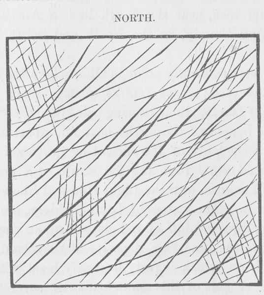
A, a, a, Ancient position of the river and shore line. B, b, b, Position of river and shore line, 1796. C, c, c, Lagoons old river bed , springs. D, Outer of the Bluffs, e, e, e, e. e, e, e, Clay bluffs and slides -- ancient and modern. Perry Monument, in Public Square. H, I, Imaginary shore line at the close of 1000 years, without artificial protection. NOTES FOR THE PROFILE ON BANK STREET. A, A, Sand and gravel stratum. A, a, a, Slide of October, 1849. B, b, Older slides on the River side. C, c, Layers of clay and sand. 1, Bones and grinder of an elephant. 2, Position of trees sticks and leaves. There is in the clay very little tenacity in a dry state and thus when the waves have dissolved and carried away the foot of the bank it breaks down by its own weight. A long narrow strip of land at the crest, suddenly drops 10, 20, or 30 feet, pushing the previous slips, a, a, a, before it into the lake. The shore lines is temporarily carried forward and a bar of clay rises above the water level. At the top of the impervious clay bed the surface water which has settled through the sandy stratum, A, A, exudes everywhere in the form of springs. This water follows the crevices of the slides continually carrying the materials into the lake. The waves act rapidly upon the foot of the slope, softening and carrying away the part which was forced up from its bed. If the lake surface falls away, a sand beach is formed, consisting of coarse littoral materials , acting as a protection to the clay and quicksand. Thus for a time the shore line remains unchanged; but a series of storms or a rise in the water, renews the undermining process, and new slides occur. When the city was surveyed the shore line was laid down by measurement on the town plat. A reduced copy of this survey made from the original which bears date, Cleveland, Oct. 1st 1796, is also inserted among the illustrations. A reduced copy of this survey made from the original which bears date, Cleveland, October 1st 1796, is also inserted among the illustrations. The plan shows what changes have occurred since the lake assumed its present general level. During the high water of 1838, the advance of the lake waters upon the town site, was so rapid that the corporation took measures to protect it. By comparing the surveys o 1796 and 1842 there had been a general encroachment of two hundred and five (205) feet., In 1806 or 1807, Amos Spafford sent his hired man, with a yoke of oxen to plow a patch of ground on the margin of the lake, which must have been not far from the Marine Hospital. At noon, the man chained his team to a tree, fed them, and went home to dinner. Returning in the afternoon his oxen were no where to be seen. Proceeding to the edge of the bank, the man discovered them still attached to the tree, quietly chewing their cuds, but the ground on which they stood had sank between twenty and thirty feet, carrying with it some of the new furrows, the trees and the oxen. Thus a belt of land about twelve and one half (121/2) rods in width was lost, along the entire front of the city. In one hundred years this would at the same rate have amounted to hundred years, have undermined the Perry monument. Before the close of a thousand years that part of the town north of Huron Street would have disappeared. The supposed new shore line and mouth of the river is shown by the line h, I, on the plan. As the ancient surface of the lake went down, the Cuyahoga river cut a deep channel in the drift clay, with steep banks from which numberless springs issued. The ever shifting channels of streams undermine their banks continually, but in a different manner and with less regularity than the lake waters. On the river side the same slides have occurred, but not as many in number for the encroachment is not as rapid. Only one has been known since the settlement of the city, which took place near the foot of Light-House street, about the year 1808. Evidences of ancient slips were, however, abundant on both banks throughout the city. There were the same succession of benches or terraces, on the river as on the lake side. Wherever excavation took place for the grade of streets, the extent and exact outline of the old slides were as apparent as those of 1849, which were observed and sketched at the time. By taking up the springs that issue at the surface of the clay, and grading the bank to an angle of about 15 degrees, a smooth grassy slope is obtained, adapted for a park of exquisite beauty. Grinders of the elephant and mastodon are common in the superficial materials, which cover the indurated rocks of the west. A grinder is said to have been found in blue marly clay on the West Side many years since. Remains of the elephas primigenius, the mastodon, megatherium, megalonyx, the horse, beaver, and some other animals, characterize the drift period. They existed prior to that geological era and through it to the alluvium, in which their bones are also found. They became extinct after the death had taken its present condition. The elephant, whose bones were discovered a few years since, in digging the coal vaults of the Merchants Bank, was about twelve feet below the natural surface. Another grinder of an extinct elephant was brought to light in the grade of Champlain street, which was about fifteen feet beneath the surface. It was secured by Dr. E. STERLING, and is now in the possession of Prof. NEWBERRY. This grinder had been worn by transportation, partially into the form of a rolled boulder; but the outlines are not wholly destroyed and the internal structure remains easily recognizable. Pieces of buried timber, sometimes whole trees with numerous leaves, also characterize the northern drift. Layers of this ancient vegetation extend beneath the entire city. The wells from which water was originally procured, were sunk through the sand and gravel bed, A, A, to one of the impervious layers, c, c, where water is always found. It was frequently impure and even offensive, from the rotten layer which lies at the surface of the clay. There is more or less of it, distributed in thin dark layers through the clay, but it has collected in larger quantities at its surface. A white cedar, twenty (20) feet in length and six (6) inches in diameter, was taken up by the late John Willis, at the depth of eighteen (18) feet, in grading the bank at the Marine Hospital. The roots and some of the branches remained, and its strength was not wholly gone. There were several shorter pieces of ancient drift wood, found at about the same depth, which show the wearing action of the ancient surf upon a sand beach, like pieces of floodwood upon the present shore. Among the leaves in the mucky layers are cedar, spruce, and pine; and these are the most common kinds of timber, found in the drift material at other places. To persons who have not become familiar, by observation, with the changes that have occurred on our planet, the assertion that there has been a period when this region was enveloped in ice, from 2,000 to 3,000 feet in thickness may appear monstrous . To those who have examined the evidences which exist, in more than half the counties of this State, in support of such a conclusion; the proof is as conclusive as it is, that in Switzerland, the glaciers of the Alps, at one time reached down into the valley of the Rhone. The slight changes of temperature which occur there now, affect the extent of the glaciers. A few degrees rise in the thermometer; diminishes the area of the iced fields; and a few degrees of depression enlarges it. In ancient times, Alpine glaciers extended across the valley at Geneva lake, carrying boulders of rocks from the summit of the Range, which were dropped in the low ground, when the ice disappeared. Beneath the present glaciers, the rocks are polished, ground and striated, by the projecting points of boulders; firmly held in the ice, as it moves towards the lower levels. The rocks in districts from which the ice has disappeared, and where there are now cultivated farms and cities, are worn and striated in the same manner. Greenland has within a few years been closely observed by Dr. Rink, a Danish naturalist and by Dr. Hayes, of the American expedition under Dr. Kane. There, a large part of a continent is found to sustain a vast glacier; which has a slow but restless motion outward toward the ocean. The cause of this motion, constitutes one of the most brilliant discoveries of Agassiz. In Greenland, there is, in places, a fringe of territory next the sea, not invaded by ice; which is variable in its extent, like that at the foot of the Alps. About 200 years since. the Moravians had mission establishments on the eastern coast of Greenland, which are now buried under snow and ice. The temperature of that country is becoming lower. The great central field of universal frost, is gaining upon the territory where vegetation exists. Towards the northern part, glaciers come to the sea, with a front of more than a thousand feet high; scratching and grinding the rocks precisely as they do in Switzerland. The push themselves along the bottom of the ocean, until there is buoyancy enough to cause them to float, when they are broken into large blocks, and range the sea, in the form of ice bergs. It is only necessary to bring the temperature of Greenland down to our latitude, and the same results would follow. The moisture of the air derived from the ocean, would be deposited upon the earth in the form of snow, instead of rain. It would thus accumulate, century after century, filling up the valleys, rising to the tops of the mountains, effectually preventing the growth of trees, and plants, and thus gradually driving men and animals from the country. Throughout the western States and Canada, are lines etched upon the rocks, the same as are seen in Greenland and on the Alps; produced by the movement of glaciers. They may be seen in hundreds of places in Ohio, when the rocky surface is cleared of its earthy covering. They are very common in the cellars at Sandusky, and on Kelly's Island, where the lime rock is thoroughly polished, having marked grooves, warped surfaces, and channels parallel to each other. On the summit of Coal Hill in Tallmadge, Summit County, Ohio, at an elevation of 625 feet above Lake Erie, and 1189 above the Ocean, the coarse grit of the coal series is smoothed and scratched over a space of several rods. At the old grindstone quarries in Euclid, Cuyahoga County they are very distinct and straight, bearing about South 20 degrees East by needle. There is a good exposure of glacial etchings on the sand rock, near the North line of Austintown, Mahoning County, in the North and South center road. The most southerly point in Ohio where they have been observed; is at Light's quarry, seven miles North of Dayton, their bearing being South 26� East. For the benefit of those who have no opportunity to examine the work of the ancient ice gravers, I insert a reduced copy from the fac simile of a polished slab of limerock, near the Light House at Sheboygan, Wisconsin. The waters of Lake Michigan, are there wearing away a bluff of red clay, of about the same height as the blue clay deposit at Cleveland; but the rock on which it rests is nearly level with the water. A belt of this scratched rock, several rods in width, recently uncovered, extends along the shore at the foot of the clay bluff, beneath which the ice etchings extend. About three miles in the interior, the Sheboygan River has cut a channel in the same red clay down to the rock,
which has a depth about the same as the valley of the Cuyahoga, within city limits. Where the rock projects beyond the clay, it is smoothed, and worn away by attrition, precisely as at the Light House, and the lines have the same direction. If the covering of clay, from the Sheboygan River to the lake shore was all cleared away, there would be several thousand acres of this polished rock exposed, of which this is intended to be a fac similie. The most conspicuous lines are due north-east and south-west, but as usual, there is more than one set. Such is the condition of the strata over the States bordering upon the lakes and the St. Lawrence. During the progress of the various geological surveys in the Northern States, and in Canada, many hundreds of observations have been made, upon the direction of these lines. Where there are hard spots in the rocks, able to resist the grinding process better than the surrounding parts; a narrow ridge is left on the southerly side, like the snow which forms in the lee of a pebble in a driving storm. The northern faces of mountains, and of rocky eminences, are abraded, while the southern faces are not. But the most conclusive evidence that the movement was from North to South, is found in the transportation of fragments of northern rocks to points always southerly from their position in situ. The boulders of Ohio are principally trap, gneiss, granite, breccia, and conglomerate; from strata that are in place on the shores of Lake Superior, and which exist in no direction. The movement was modified by the topography of the country, pursuing in general, the course of the great valleys, such as those of the Kennebec, the Connecticut, and the Hudson Rivers. In New England, the ice marks are found at an elevation of 3000 feet above the sea, which is higher than the highest land in the western states. In the valley of the St. Lawrence, the course of the movement was south-easterly until, the east end of Lake Ontario is reached. At Buffalo, it was South 30� West. On Lake Superior it had the same general bearing, except in the minor valleys, or where mountains turned it aside temporarily. The opening between Lake Huron and Lake Michigan, at the Straits of Mackinaw, gave it a westerly direction, as far as the mouth of Green Bay. On the summit of the Iron Mountains of Marquette County, Michigan; of the Copper Range of Point Kewenaw, and the Mesabi Range in Minnesota, the markings are as distinct as they are at Lake Erie; and their bearing is uniformly south-westerly. How the change of temperature, of the glacier epoch was brought about is a question still under discussion. Such changes have occurred much earlier in the history of the earth, and are probably due to astronomical causes; involving immense periods of time. During the era of the coal, a tropical climate existed as far North as Melville Island, in the Arctic Sea. The origin of motion in such wide spread fields of ice, is thought to be understood. Agassiz spent several seasons in the Alps observing the movements there. He has demonstrated that the expansion which arises from freezing at the center of the mass, find relief only towards the edges, and consequently, on the side which is thawing, there must be motion. This is very small but irresistible, and continuing for thousands of years in one direction, produces monstrous results. If an ice field enveloped the northern hemisphere, its thawing edge would be on the side of the equator. Consequently, the movement would be southerly, and would be greatest along the front, where dissolution was taking place. But the line of equal temperature, are not coincident with parallels of latitude. Across this continent and through Europe, they are oblique, bearing to the North as we proceed westward. This was probably the case, at and before the age of ice. Thus the southerly edge of the continental ice field, would not bear East and West, but north-westerly and south-easterly, modified by the elevation of the country. In that case, the motion would be at right angles to the Isothermal lines, or from north-east to south-west. There is an exception to this, in the bearing of the stria across the westerly part of Lake Erie, but here the Southern limit of the boulders of northern rocks, forms a curve, and is nearly parallel with the southerly shore of the lake. Such is supposed to be the manner in which the beds of clay, sand and gravel were formed, on which the city of Cleveland rests. PRE-HISTORIC INHABITANTS. Throughout the southern half of Ohio, there are remains of earth works constructed by a people of whom we have neither history or tradition. All we know of them, is what may be deduced from the character of these ruins. Some of them are in groups occupying several hundred acres. They consist of mounds, lines of embankments, either single, double or treble; sometimes with ditches, but more often without. When without ditches, they resemble a turnpike, but such was not their original design. They both straight and curved, generally forming an enclosed figure, approaching to mathematical regularity; such as a rectangle, octagon, circle or ellipse. A partial enclosure in the form of a horse shoe, or a segment of some regular figure is common. Although mounds and banks of earth, are as nearly imperishable as any structure raised by man, they are more or less obliterated by rains, frosts and other atmospheric agencies. Some of the parallels require close examination to detect, and especially to follow them; through cultivated fields, herbage, and the undergrowth of western forests. Ditches and pits are sooner obliterated than works in relief. On these ruins, the timber is of the same size and character, as it is around them. Trees 400 years old have been cut down, whose roots were fixed upon the top of embankments, where the remains of previous generations of trees, were also visible. There is evidence to show that the race of red men, whom Columbus, De Soto and John Smith, encountered on this Continent, had then been here fifteen or twenty centuries. The Aborigines had no knowledge, and no received traditions of their predecessors; which they must have had, if the race of the mounds were their ancestors. Everything which remains of the mound builders, indicates a people of higher cultivation than that of the Indians. The more ancient race were industrious, cultivating the soil; not wandering hunters. They erected mounds of earth, which are in some instances from sixty to seventy feet high, with a circumference at the base of seven hundred and eight hundred feet. These are still quite imposing piles, rising nearly to the tops of ancient trees, among which they stand. A single fortification on the bluffs of the Little Miami, called "Fort Ancient," in Warren county, Ohio has a parapet which in some places is eighteen feet high, and fifty feet thick at the base. The entire work, is computed to contain six hundred thousand cubic yards of embankment, and would allow of twenty thousand men for its defense. Near Newark there is a circle, one-fourth of a mile in diameter, where the bank is at the highest point, twenty-six feet above the bottom of the ditch. This people has left numerous ruins, not only over the southern half of this State, but throughout the low lands of Kentucky, Western Tennessee, Southern Indiana, Illinois, Missouri, Arkansas, Texas and Mexico. The large cities, if we may judge by their position, were selected on the same principle by which our fathers selected theirs. Extensive ruins were once visible, on or near the sites of Cincinnati, Marietta, Portsmouth, Chillicothe, Circleville, Dayton and Newark. They were contiguous to large tracts of good land upon valuable water courses. The same people worked the copper mines of Lake Superior. Many of their mounds, are monuments raised to the dead, where valuable relics were placed ; consisting of beads and shells and plates of native copper and silver. Their tools are of copper, which appears to be the only metal they had for implements. They forged of it spears , arrow heads, axes, chisels, spades and gouges in its native state, never having been melted or refined. Their tools are found, not only with the ashes of their dead, but on the surface, in the vicinity of their works. Very good cutting tools were made of stone, of which great numbers have been found. The race of red men had also stone axes, knives, spear and arrow heads, but did not possess implements made of copper, with the exception of some very rude knives, found among the tribes inhabiting Lake Superior. Here the Chippewas have sometimes fashioned and awkward knife, or an instrument for dressing skins, from nuggets of native copper which they found in the gravel. The style and finish of their rough knives, enables one at once to separate them, from the more perfect work of the mound builders. This difference of mechanical perfection, aptly distinguishes the civilization of the two races. The North American Indian principally upon flint, which the race of the mounds used very sparingly. As implements of wood soon perish, we have little trace of them , although they must have been numerous. Some of the wood shovels and bowls, which they used in the mines of Lake Superior, have been preserved beneath the water and rubbish of old mines. A part of the decayed handle of a copper spear, was found in the same situation. In the north eastern part of Ohio, in the county of Geauga, a war club of Nicaragua wood, was discovered early in the settlement of that region. This might have belonged to either of the races, which preceded white men on this soil. Wooden ornaments and implements, not being so precious, were not buried with the dead. If they had been, there are cases where something would remain of them. Threads of hempen cloth, and timber forming a sort of coffin or vault, have, in some case, resisted decomposition. So has their ornaments of shell, bone and stone; and their pipes, grotesquely carved with images of animals. All these relics, show a condition advanced beyond the people, called by us the Aborigines, who were the second, perhaps the third, race which preceded us. Along the south shores of Lake Erie and Lake Ontario, are numerous ancient works; but of a character different from those on the waters of the Ohio. There were two of them within the limits of the city of Cleveland. A low mound was visible within the last twenty years, on the lot at the south east corner of Erie and Euclid streets. But the mounds, embankments and ditches, throughout the lake country are insignificant in size, in comparison with those in the southern part of the State. Most of those in New York and the northern part of Ohio, are fortifications; while a large part of those farther south were not designed for the purposes of war. Many of the latter had reference to religious ceremonies and sacrifices, probably of human beings. There is a wide belt of country through central Ohio which is nearly destitute of ancient works, as though there was a neutral tract, not occupied by the ancient races. Those on the waters running northerly into the lake, are generally in strong natural positions. They may still be seen on the Maumee river, above Toledo, and on the Sandusky, Huron and Black rivers. A group of these enclosures existed at the forks of Huron river, where the road crosses, about a mile and a half west of Norwalk. As a sample of ancient forts in the lake country, I insert plans of some of those which are not yet destroyed.
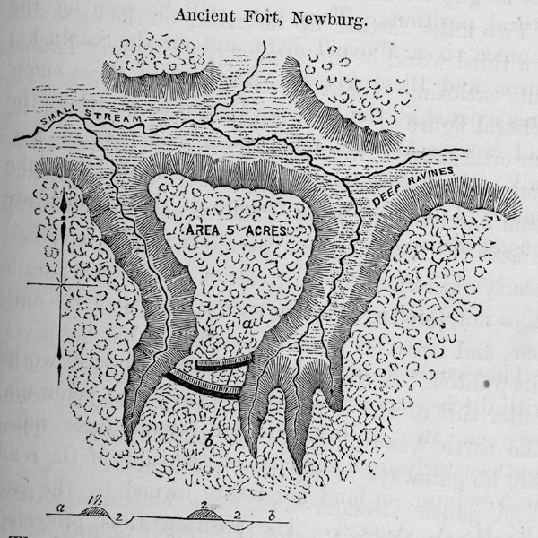
ANCIENT FORT, NEWBURG This consists of a double line of breast works with ditches across the narrow part of a peninsula, between two gullies, situated about three miles south-easterly from the city, on the right of the road to Newburg on land heretofore owned by the late Dr. H. A. Ackley. The position thus protected against an assault, is a very strong one, where the attacking party should not have projectile of long range. On three sides of this promontory, the land is abrupt and slippery. It is very difficult of ascent, even without artificial obstructions. Across the ravine, on all sides, the land is upon a level with the enclosed space. The depth of the gully is from fifty to seventy feet. About eighty rods to the east, upon the level plain, is a mound ten feet high and sixty feet in diameter. At the west end of the inner wall is a place for a gateway or passage, to the interior.
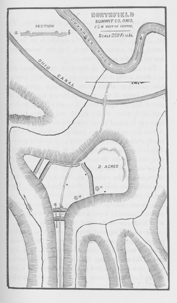
The height of the embankment across the neck is two feet, and the enclosed area contains about five acres. Perpetual springs water issue from the sides of the ravine, at the surface of the blue clay, as they do at Cleveland. About six miles from the lake, on the eastern bluffs of the Cuyahoga river, is a similar work that has but one line of embankment, with a ditch. The bluffs are higher, but not quite as inaccessible as on the Ackley farm. About the middle is an unexcavated space across the ditch, but the breast work has no gap for an entrance. Two miles farther up the river, on the same side, is third work, in the same style, similarly located, but enclosing about twice as much space. The general figure of the enclosure is very much like the one on Ackley's premises. Two small branches head ear each other at the upper end of two ravines, from one hundred to one hundred and fifty feet deep. Across the neck are two parallels, which have been nearly obliterated by cultivation. the inner parallel does not appear to have been as high as the outer one, and between them was a broad, but not a very deep ditch. A conspicuous ditch was made on the outer side of the outer wall, from which, no doubt, the earth was taken for the embankment. There are no gateways in either of the walls. A much stronger and more elaborate fortified position, exists in Northfield, Summit County, on the river bluffs, two miles west of the center. A road leading west from the center to the river, passes along a very narrow ridge, or "hogs back," between two gullies, only wide enough for a highway. Before reaching the river bluffs, this neck of land expands right and left, where there is a level space of about two acres, elevated near two hundred feet above the canal and river.
Where this area begins to widen out on the land side, there are two lines of banks, with exterior ditches, which are forty feet apart, and extend across the neck, without entrances or gateways. From the top of the breast work to the bottom of the ditch, is now from four to five feet. Mr. Milton Arthur, the owner of the land stated, that before the land was cultivated, a man standing on the ditch could not look over the wall. On all sides, the flat land is bounded by gullies, eighty to one hundred feet deep, except where it is joined to the ridge. There is permanent water in the ravines. The earth of the bluffs is so steep that it is subject to slides. It is remarkable that there is, within this area, another set of lines on the side towards the river, reducing the fortified area to about one-half the space, whose edges are at the bluffs. Two projecting points art cut off by these lines, and left outside the woks. In this way, much of the natural strength of the position is lost. At these places, there are pits, which the early settlers of Northfield say were filled with water, and were stoned around like wells. There are also two low mounds, m, m, on the east side. Where the bluff is not as steep as it is elsewhere, there is a parapet thrown up at the crest. A part of earth on the north side and west side, was taken from the inside, which indicates a state of siege, or at least some pressing haste when this part of the line was finished. Perhaps their enemies had gained a foothold in the level space outside the lines. On the west side of the river is another ancient fortification, opposite this, and it is stated there is in the township of Independence, on the bluffs, north of Tinker's creek, near its mouth, another work of the same character. There are no doubt others which are known to inhabitants not yet surveyed or described.
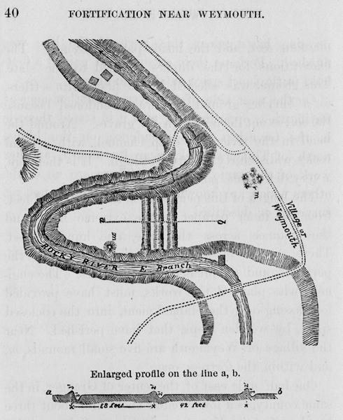
A short distance east of the village of Weymouth, in a bend of the Rocky River, is a fortified point of land, with three lines of banks and ditches. From the outer to the middle one is forty-two feet, and thence to the inner parallel, thirty-eight feet. In 1850, the outer and the inner lines were in the best condition. From the top of the outer wall to the bottom of the ditch, is five feet; of the middle one four feet, and the inside parallel six feet. The excavations for the ditches reached to the slate. This ground was selected by the first white settlers, for a burying ground, but was abandoned because the soil is not deep enough for graves. Around the bend in the river is a deep channel, with vertical rocky walls, thirty to fifty feet high. It is therefore, a very defensible position. The length of this peninsula is three hundred feet, from the inner parapet to the extreme front, and the distance across the base, one hundred feet. There are no openings or gateways through the parallels, and no breaks in the ditches. The engineer who planned the works, must have provided for passing over the embankment, into the enclosed space, by wooden steps, that have perished. Near the village of Weymouth are five small mounds, m, and within the fortress, one. One-half mile east of the center of Granger, in the same county, is a low circular enclosure, about three hundred feet in diameter. It has a slight exterior ditch. There is an opening for entrance on the north-west side, near where the east and west road crosses the work. Two small streams of living water pass along the sides of it. The situation is low and flat, with a slight rise on the west, which overlooks the interior of the enclosure. It possesses no natural strength of position, and was doubtless designed for other purposes than defence. FORT NEAR PAINESVILLE.
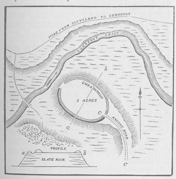
On the west bank of Grand river, about three miles east of Painesville, is a narrow peninsula of soap stone and flags, which has been fortified by the ancients. A tall growth of hemlock furnishes a refreshing shade, to which the citizens resort for May-day pic-nics, and Fourth of July celebrations. A small creek runs outside the point, which is about 200 feet wide by 600 in length, entering the river at the apex. The elevation is from 40 to 60 feet above water level. At the extremity of the point is a lower bench, across which is a low bank and ditch. About 400 feet farther back from this are two parallels across the peninsula, which are 86 feet apart. In most places it is nine feet from the bottom of the ditches, to the summit of the walls. All the ditches are on the outside and are well preserved. There are very few places where a party could climb up the soap stone cliffs, without the aid of trees or ropes. The course of this projecting point is east and west, joining the mainland on the west. In this direction there is higher land within 300 feet of the outer parallel. FORTIFIED HILL NEAR CONNEAUT. On the south side of the creek above the village of Conneaut, in Ashtabula county, is a detached mound of shale, about seventy feet high, which is crowned with an ancient fortress, or strong-hold, represented in the plan here inserted.
On the north side there is a low bank of earth following the crest of the hill. There is here no berme, or level space, outside of the embankment. On the south side, where the bluff is not as steep and difficult of ascent as on the north, there is a ditch between the parapet and the crest, as represented in the profile, a, b. Outside of the ditch is a low bank on the edge of the natural slope. Thus the side having the least natural strength, was made stronger by art. It would be almost impossible, for men to ascend the steep escarpment of soap stone on the north. A narrow ridge of gentle ascent, allows of an easy grade on the south-eastern side, where there was in 1840, the remains of an ancient road. This leads to the gateway at c, where there must have been some obstructions of wood like a "porte cullois," which inmates could open and close at their pleasure. Why there should have been an opening in the enclosing wall, at the end next the river is not apparent. Within the enclosure, embracing about five acres, the soil is black and rich, while it is clayey and lean without. This is a common feature of the old earth-works on Lake Erie. It indicates a lengthy occupation of the place, by human beings. The ground occupied by Indian villages in the north, is always more fertile than the same soil outside of their towns. In the valley of the creek, there is much good land which the ancients no doubt cultivated. These strong natural positions, resemble the fortified villages of the Moques, on the waters of the Colorado; which were visited and described by Prof. J. S. Newberry in 1854. If the North American Indians, had been found intrenched in earth-works, when the whites first knew them; or possessed traditions concerning them, we should attribute the small forts which are upon the waters of Lake Erie, to them. But I have not seen among descriptions of the early French writers, any thing of the kind more permanent than pickets an stockades. EVIDENCE OF THE PRESENCE OF WHITE MEN NOT KNOWN IN HISTORY.
In 1840, I was requested to examine the stump of an oak tree, which was then recently cut; and which stood in the north-west part of Canfield, Mahoning County, about fifty miles south-east of Cleveland. The diameter was two feet ten inches when it was felled, and with the exception of a slight rot at the heart, was quite sound. About seven inches from the center were the marks of an ax, perfectly distinct; over which one hundred and sixty layers of annual growth had accumulated. The tree had been dead several years when it was cut down, which was in 1838. When it was about fourteen inches in diameter, an expert chopper, with an ax in perfect order, had cut into the tree nearly to its heart. As it was not otherwise injured the tree continued to grow; the wound was healed, and no external signs of it remained. When it was felled, the ancient cut was exposed. I procured a portion of the tree extending from the outside to the center, on which the ancient and modern marks of the ax are equally plain; the tools being of about the same breadth and in equally good order. Soon after this I received from JASON HUBBELL, Esq., of Newburg, in this county, a letter describing some ax marks which he had observed, in a large popular tree situated in that township. In this case the tree was larger, but Mr. HUBBELL considered the age of the cutting, to be from one hundred and fifty to one hundred and sixty years. Mr. STEPHEN LAPHAM, formerly of Willoughby, Lake county, now of Janesville, Wisconsin, presented to Prof. J.L. CASSELLS a portion of a hickory tree, the stump of which still remains, a few feet from the railway, a mile and a half west of Willoughby. In a letter to me, Mr. LAPHAM says, "it was cut in May or June, 1848 or 1849, on the farm I then occupied. I sent a hired man to cut some wood, and directed him to fell this tree, which was about two feet diameter. I saw the tree fall, and measured the length of the wood he was to cut. As the man cut in near the heart, I noticed ancient ax marks. It had been cut into when a sapling about four inches in diameter. There was the old dry bark on the tree, above and below the old cut. There was eleven inches of growth outside of the cut, and about forty-six rings or layers to the inch. The tree was green and sound when it was cut. I preserved the piece near the heart, with the old marks on it." I examined this stump in 1859, and now have the piece which Mr. LAPHAM preserved. It was difficult to count the layers of annual growth, but there were more than four hundred. Mr. LAPHAM was of the opinion, that the first chopping was done before Columbus landed on this continent. If so it cannot have been the work of white men. The style of the cut is that of a perfectly sharp ax, in all respects like the work of a good chopper of our times. Although the rule is, that one layer of growth accumulates each year, there are exceptions, though they are very rare. Four hundred years before 1848 would carry us back to 1448, forty-four years before the island of St. Salvador was discovered.
There are trees which form two terminal buds in a year, and in that case two layers of growth are formed. If it was so in this case, the time elapsed would be two hundred years, instead of four hundred, and the date would be about 1648. Another instance of the work of old choppers, is furnished in the following letter from H.L. Hill, Esq., of Berlin, Erie Co., O.: BERLIN HEIGHTS, Jan. 23, 1859. In the summer of 1831, I felled one of the giant oaks of the forest, which was about three feet in diameter. It was cut for the purpose of making wagon hubs. One cut or length, was sawed off, the size of the hubs marked out, leaving six to ten inches around the heart. As we split the bolts, three cuts or strokes, of a sharp narrow bitted ax were plainly visible, the chips standing outward from the tree as distinct as when they were first made. My brother and myself counted two hundred and nineteen rings of annual growth outside of the cuts. It was with the greatest difficulty, we were able to count the fine growths near the butt of the tree, and may have made a mistake of a few years. The tree stood on lot seven, Range seven, Berlin township, on a dry piece of ground, nearly surrounded by wet land; for about twenty rods forming good ground for a camp. In the spring of 1857, I pulled out the stump of this tree, and in plowing through the ground where is stood; turned up the ax you saw in the museum. I think it must have been between the roots of the tree, or we should have seen it before. Yours respectfully, .L. HILL.
If the cuts mentioned by Mr. Hill, were made by the Indians with their rude squaw axes, they possess no special meaning. Those upon the Canfield and the Willoughby trees were by a different tool, a well formed ax, with a clear sharp cutting edge. Very soon after French and the English encountered the Indians 1608-20, they were furnished with squaw axes. These axes were narrow bitted, made of iron or inferior steel, and were never kept in order by the Indians. Where they have used them upon modern trees, the style of the stroke at once shows it to be this kind of tool. It is never sharp enough to cut a surface smooth, like a modern choppers ax. The Jesuits were among the Iroquois of Western New York as early as 1656, but we have no historical traces of them as far west as Ohio. The Canfield tree must be considered a good record as far back as 1660. Many historians infer that LA SALLE passed through Northern Ohio, from the Illinois river in the winter of 1682-83. That he made a journey by land from Crevecoeur to Quebec in that winter cannot be doubted, but there is no proof on which side of Lake Erie he traveled. It is far more probable that he avoided the hostile Iroquois, and bearing northward crossed the Detroit river, where the Indians were friendly to the French. A hasty traveler like him, could have left few marks of his ax. There must have been hundreds of trees on the Western Reserve, upon which axes had been used, in order to furnish us, so many examples after a lapse of two centuries.
|
||||||||||||||