|
EARLY MAPS OF THE LAKE COUNTRY.
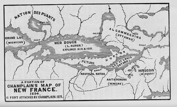
Upon the geography of the region of the Lakes, there is nothing, based upon personal observation, earlier than Champlain's map, a portion of which is given on the next page. He spent his life among the Indian tribes of the valley of the St. Lawrence, either in a friendly or a warlike character. Those on the North or the St. Lawrence,(originally St Laurent); were secured to the French interest by his personal influence. He always went with them across the river southward, to make war upon their enemies, the Iroquois, who were friendly to the English. In 1634, Champlain published his map of New France. The French had not, at this time , dared to venture upon Lake Erie, neither had they the benefit of information from Indians, who lived upon its shores. In his expedition of 1615 against the Onondagoes, on the waters of the Oswego River, and the Senecas at Canandaigua Lake, Champlain obtained some knowledge of that country.
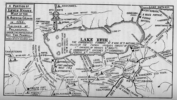
His route is shown on the map by dotted lines; and the position of the Seneca Fort by the letter a . From the country of the "Antoronons" or Senecas, on the head of the Genessee River; and of the "Carantouannais," on the head waters of the Susquehanna, an Indian road or trail, led away to the westward, and the streams running north into Lake Erie. The Falls of Niagara are noticed only as a rapid or sault, like the other rapids of the St. Lawrence. From thence, a grand strait, with Islands, connecting Lake St. Louis, or Ontario with Lake Huron, is all the representation given of Lakes Erie and St. Clair. Champlain only knew that his "Mer Douce" had a connection with Lake Ontario , but of the existence of another great lake, between them, he was clearly ignorant. His route to Lake Huron was always through the friendly tribes, by way of the Ottowa River, and "Lac de Biserenis" or Lake Nepissing. Evidently, he had not explored the "Grand Lake" (Michigan) or Lake Superior. The "Puants" or Winnebagoes, who occupied the north-western parts of Lake Michigan, he supposed were north and east of Superior. The Chippeways, Ojibways, or Sauteurs, were at that time, as they have been since, the masters of the shores of that lake. If Champlain had been upon the waters of Lake Michigan, he would not have put the sault, at the outlet of that lake, instead of Superior. Neither would he have represented the last named lake, as a diminutive body of water, not larger than Lake Nepissing. The fact of the existence of copper, he derived from the Indians. But grotesque as his map appears to us, it possesses much interest. It shows where the savage nations were located, whey they were first encountered by the whites. The Iroquois held the waters of Lake Champlain, the Hudson River, and the Upper Susquehanna. On the North Shore of Lake Ontario were the Hurons, afterwards known as the Wyandots. On the North Shore of Lake Erie, the "Petuns," or Tobacco Indians were located. Not long before the Iroquois achieved their first great victory over the Eries, which occurred about 1655, they expelled the Neutral Nation from the shores of the Niagara river. The Iroquois called the Neutrals, the Nation of the "Cat," meaning the wild cat, an animal of the family of the lynx. By the French, the Eries were also known as Cats, but this name they applied to the raccoon. In this way, the two Nations are confounded. Their fate was alike, but they were not even allies. The Eries, under the name of Erigas, remained a long time in Ohio, having been driven from the Genessee river, past Buffalo, to the heads of the Scioto. They were originally of the Iroquois stock, speaking a dialect of the same language. As usual, when people of the same lineage become enemies, their hatred is more fierce and lasting than where there is no community of blood. At the eastern end of Lake Michigan, a great river comes in from the South, whose head waters are as low in latitude as the capes of Virginia. A large river discharges into Lake Huron, near the western portion, opposite an island. On this is located the "Gens de Feu," or nation of the Fire, since called the Mascoutens. Another large river from the south, discharges into what answers to Lake Erie. On the sources of the three last named streams was the nation "which has plenty of Buffaloes." Numerous Indian villages, fields, and graves, are represented on these rivers, and throughout all the country. There are also abundant mountains, in all parts of the western and north-western country, as well as in New England and Virginia. LEWIS EVAN'S MAP-1755. Neither had the English much reliable knowledge of Lake Erie, until after the year 1700. As soon as peace was secured by the French, with the Iroquois, they hastened to possess the country west of the Allegheny mountains. The English were equally hasty in opposing them. Lewis Evans, of Philadelphia, assisted by Governor Powwall, of New Jersey, between 1740 and 1750, gathered materials for the map of 1755. Captain Thomas Hutchins, who was the Engineer to Colonel Boquet's expedition of 1764, also published a map, embracing a part of Lake Erie, and the Upper Ohio. John Fitch, the great American improver of steamboats, and who invented more of its useful parts than any other man, published a map of the Ohio country in 1784 or 1785. In March, 1780, he was made prisoner by Indians, at Blennerhasset's Island, near Marietta, on the Ohio, and taken by them through the country to Detroit. He obtained from them what information he could; drew, engraved and printed, the map with his own hands. Evans included in a general sketch, all the country westward from the sea coast, to the Mississippi River, which is remarkably accurate. His detailed map extends no farther West than the Great Miami. As early as 1670, the Jesuit Fathers published a map of Lake Superior, which appears to have been corrected by celestial observations. It seems impracticable to construct a chart of so large a tract, with so much geographical accuracy, without such corrections. The positions of important points on Evans' map, do not appear to have been determined by astronomical instruments; but his sources of local information, must have been very numerous and reliable.
His title is quite a geographical memoir, and reads thus: "A GENERAL MAP OF THE MIDDLE BRITISH COLONIES IN AMERICA, VIZ: VIRGINIA, MARILAND, DELAWARE, PENSILVANIA, NEW JERSEY, NEW YORK, CONNECTICUT AND RHOD ISLAND; OF Aquashuonigy Country, of the Confederate Indians, comprehending Aquaishunigy proper, their place of residence; Ohio and Tiiuxsaxrunthe, their deer hunting country, Couxsaxrage and Skaniadarade, their beaver hunting countries of the Lake Erie, Ontario and Champlain, and a part of New France; wherein is also shown the ancient and present seats of the Indian Nations." NOTE.-"The Confederates, July 19, 1701, a Albany, surrendered their beaver hunting country to the English , to be defended by them for the said Confederates, their heirs and successors forever, and the same was confirmed Sept. 14, 1728, when the Senecas, Cayugaes and sixty miles inland to the same for the same use." A comparison of the early maps, gives the best history of the migrations of Indian tribes. Their rapid extinction, is also made conspicuous by such comparisons. In place of the "Petuns" of Champlain, on the North of Lake Erie, towards the Falls of Niagara, are, according to Evans, the "Sissisoquies." Between the Oswego and Genessee (Kashuxca) Rivers are the "Cayugaes"; on the heads of the Genessee, the Senecas; and in Ohio, the Erigas, or Eries. No notice is taken of the Neutral Nation. The "Chawanes'(Shawnees and Shawanese,) were then on the Ohio, around the mouths of the Scioto, and the Kenhawa. On the Great "Mineami," (Miami,) were the "Tawixtawis," and the Mineamis. The Hurons, Wyandots, or "Wiandots," had been pushed from the North Shore of Lake Ontario, to the western part of Lake Erie, embracing both shores. For local details, the map of Evans' is a great advance upon Champlain's. The outlines of Lake Erie are too large every way, but the resemblance to nature is easily traced. Several of the Indian trails and portages are given, showing their principal routes of travel, by land and by water A great war path extended southerly from the Tawixtawi towns, at the Forks of the Maumee, to the French post on the Great Miami; afterwards known as Loramies; thence to the mouth of the Scioto, and to the Blue Licks in Kentucky. From Loramies or the Piqua towns, another led eastward to the Delaware towns, on the Scioto; and thence across the Hockhocking, probably at Lancaster, to the White Woman's town, at the forks of Muskingum, near Coshocton. Coal is laid down on the Tuscarawas, near Bolivar; petroleum on the Ohio, near Yellow Creek; and salt water on the Mahoning River, in Trumbull county. At the issuing of this map, the French were in possession of all parts of Lake Erie, and its waters. No Englishman had traversed this country, unless it was some unknown prisoner among the Indians. The first of these we know of, was here in 1754-5. Huske's map prefixed to Douglass' summary; a general history of North America, 1760, has the following title: "A Map wherein the errors of all preceding maps, British, French and Dutch, respecting the rights of Great Britain, France and Spain, and the limits of each of his Majesty's provinces are corrected." Carrying Places Between the Ohio and Lake Erie. From the Topographical Description, &c. By Capt. Thomas Hutchins, 60th Regiment, London, 1788. "The Canawagy Creek, (Chatauque) when raised by freshets, is passable with small batteaux, to a lake, (Chatauque) from whence is a portage of twenty miles, to Lake Erie, at the mouth of the Jadagque, but this is seldom used, as the Canawagy has scarcely any water in a dry season." Chatauque is no doubt derived from "Jadagque," or "Jadaixqua, according to Evans. "French Creek affords the nearest passage to Lake Erie, being navigable by a very crooked channel, with small boats to Le Beuf. The portage thence to Presque Isle is fifteen miles." "Beaver Creek has sufficient water for flat boats. At Kishuskes, about sixteen miles up this creek, it has two branches, which spread opposite ways. One interlocks with French Creek and Cherage; the other with Muskingum and Cuyahoga, on which, about thirty-five miles above the forks, are many salt springs. It is practicable for canoes about twenty miles further." "From Muskingum to Cuyahoga, a creek that leads to Lake Erie, which is muddy and not very swift, and nowhere obstructed with falls or rifts, is the best portage between the Ohio and Lake Erie." "The mouth is wide and deep enough to receive large sloops from the lake, and will hereafter be of great importance." "The lands on the southern shore of the lake, and for a considerable distance from it, for several miles East of the Cuyahoga, appear quite level, and are extremely fertile." EXPEDITIONS OF MAJOR ROGERS, MAJOR WILKINS, AND COL. BRADSTREET. 1760, 1763, 1764.
In reference to the English expeditions into the lake country, which followed the French War, I have not space to notice them fully. Major Robert Rogers, of the Provincial Rangers, which were raised in New Hampshire, left Fort Niagara with his battalion in October, 1760, to take possession of the French Posts. The command sailed in batteaux, capable of carrying fifty men, which coasted along the south shore. When the wind was fair they made good progress; if it was unfavorable, their boats having sails were capable of beating against the wind. Major Rogers was a bold, restless, enterprising, intriguing man, who had served with distinction in the French War. He traveled extensively throughout the lake country, and published two volumes in reference to it in 1765. His Journal of the expedition to Detroit is very full. It contains the progress of nearly every day, with the courses and distances made on each stretch by the boats. Historians have assumed, that the celebrated meeting of Pontiac, "Pondeach" or "Ponteach" with Major Rogers and his Rangers, haughtily demanding by what authority the English troops entered this country, occurred at the mouth of the Cuyahoga. "On the 7th of November, 1760, they reached the mouth of the Cuyahoga river, the present site of Cleveland. No body of British troops had ever advanced so far. The day was dull and rainy , and, resolving to rest until the weather should improve, Rogers ordered his men to prepare their camp in the neighboring forest. The place has seen strange changes since that day." "Soon after the arrival of the Rangers, a party of Indian chiefs and warriors entered the camp. They proclaimed themselves and embassy from Pontiac, ruler of all that country, and directed, in his name, that the English should advance no further until they had had an interview with the great chief, who was close at hand. "He greeted Rogers with the haughty demand what his business was in that country, and how the dared to enter it without his permission." (Parkman's Conspiracy, pp. 147-148.) Rogers himself leaves the place of this meeting in much obscurity. In his Journal he does not speak of Pontiac, but in his "Concise Account," published in the same year, that warrior, with his lordly bearing, is made conspicuous. The place where the interview was held is not described. "Nov. 4th, 1760, set out from Presque Isle, (Erie) and made about twenty miles. Nov. 5th, lay by on account of the weather. Nov. 6th, advanced ten or twelve miles. Nov. 7th, set out early and come to the mouth of the Chogage river. Here we met with a party of Attawawa Indians, just arrived from Detroit." (Rogers' Journal, p. 214.) After some parley, the Indians held a council, and promised an answer the next morning. Nothing is said of the Chief, or of their assuming a threatening attitude. In the morning, they gave a reply, and said their warriors should go with the party. They were given presents, and charged to prevent annoyance on the way, by sending some sachems with Capt. Brewer, who was driving the cattle along shore. Major Rogers was detained at "Chogage" until the 12th. That day, by his reckonings, stearing various courses, he made forty-one miles and reached "Elk river, as the Indians call it." Elk river, or "Elk creek" upon Evans' map, is east of Cuyahoga. During the 4th, 5th and 6th of November, Major Rogers had advanced from thirty to thirty-two miles, which did not place him beyond Conneaut creek. How far he moved on the 7th, is not stated. From Conneaut creek to Grand River, is forty-miles; and thence to Cuyahoga, thirty miles. Could he have made seventy miles on the 7th? I so excellent a day's work had been done, would not Major Rogers have made note of it? By his reckoning, it is forty-one miles from "Chogage" to the Elk, a distance which they accomplished on the 12th; but this includes the several courses run by his fleet of boats, standing out and in to keep the wind. eHHHHlllllhhhHHHHHlllllkkjjjhhhhhhgjjjjjdkjjf He did not advance this distance in a direct line along the shore, probably not more than thirty miles, or from Grand River to Cuyahoga. From his Elk creek to Sandusky bay, is fifty miles, as the boats ran ; only two rivers having been observed on the way. His failure to note the distance which they made on the 7th, leaves the record very incomplete. On none of the early maps is Elk river laid down west of the Cuyahoga. In Kalm's travels, (London, 1771,) it is placed first on the east. Upon Jefferson's map, (Notes on Virginia, 1787,) it is the third river east of this; and on Harris' map, (1803,) the fourth. In Morse's Geography, (London, 1792,) there is neither Cuyahoga or Elk rivers, the Grand river being farther west than the Cuyahoga should be. It would be a very good day's sail in batteaux, to reach Grand river from Conneaut creek. The computed distances from thence to Sandusky, are approximately correct, which leaves a fair presumption in favor of the mouth of Grand river, at Fairport, as the place where the Ottawas held their first interview with the English troops. But comparing all of Rogers' statements in regard to this expedition, which are not entirely consistent, it is by no means clear that Pontiac was a party in this interview. On the morning of the 20th, the command left a river, about ten mile east of Sandusky bay, (Huron river,) encamping that night at the second stream beyond the bay, which should be the creek next west of the Portage, or "Carrying" river. Here Major Rogers was met again by an embassy, who demanded his business there, representing that they spoke for four hundred warriors, who were at the mouth of the "great streight," to obstruct his passage. He quieted the sachems by explanations and promises, and on the 21st, they all set forward in good humor. (Rogers' Journal, p.218.) At "Cedar Point," on the night of the 23d and 24th, the same messengers returned, among whom was a sachem of the "Attawawas." The next morning sixty Indians offered to escort the English to Detroit. Pontiac is nowhere mentioned. If he was present at a meeting east of Cuyahoga, he was out of the country of the western Indians, and had no right to question the conduct of the British commander. Until after passing that stream, he was in the Territory of the Six Nations, from which they had driven the Hurons long before, making the Cuyahoga their boundary. All this must have been well known to Pontiac, and to Major Rogers. Sir William Johnson, while he was Superintendent of Indian affairs, made a journey from his home, on the Mohawk, to Detroit, the next season after the English obtained possession of that place. On his return, by way of the south shore, in the summer of 1761, his Diary has the following sentence" "Embarked this morning at six of ye clock, and intend to beach near Cayahoga this day." The Cayahoga" is a prominent river on Evans' Map, published five years previous. It was well known to Johnson and to Rogers, who describes the country adjacent, in his "Concise Account." If the interview with Pontiac had occurred here, a place already notorious among the Indians and well known to geographers, it would have been properly named. As a misprint, Chogage, is too far from Cayahoga, to warrant the conclusion that the words were meant for the same. Sheauga, the Indian name for Grand river, is much nearer both in sound and orthography. For the present, therefore, something, must be left to conjecture, in reference to the spot where this great Indian warrior and medicine man, asserted his ideas of the supremacy of his people. Finding himself grievously mistaken, he soon concocted a great conspiracy of the north-western tribes, which burst forth simultaneously, upon every English garrison and trading post in the spring of 1763.
For further reading: Encyclopedia of Cleveland History
|
||