|
CONNECTICUT LAND COMPANY.
According to this record, the number of original parties was thirty-five, although it is generally represented as thirty-six. There were this number of bonds given to the State by them, for the above stated sums; which were secured by personal security at first, and afterwards mortgages upon the land. The first purchasers, however, represented other persons who were also constituted members of the company, fifty seven in number. The different grantees in the deeds from Connecticut, gave the Trustees a list of the persons whom they represented, and the accordance with the articles of the association. Some of those who had given their bonds failed; and others persuaded the State to accept bonds and mortgages from them individually. They gave a bond to the Treasurer or State, and a mortgage of the lands which were aparted to them in severalty under the draft of 1798, east of the Cuyahoga. They gave also another style of security, called the "Trust and benefit mortgages," covering their interests in common then undrawn. These were so worded, that the Trustees of the Land Company, after draft, made another mortgages to the State, in which the original purchasers had the right of redemption. [Leonard Case.] A partnership, or association, was immediately formed by the purchasers; who called themselves the "Connecticut Land Company"; all of whom joined in a deed of trust, to John Caldwell, Jonathan Brace, and John Morgan, covering the entire purchase. As special corporate powers were not given them by the Legislature, and doubts existed as to the validity of their political franchises; this course was necessary for the convenient management of their business. The trust deed bears date September 5, 1795, and with few exceptions, the deeds of the Trustees are the source of title, to lands on the Western Reserve. As late as 1836, all of the original Trustees were living and joined in deeds of lands within this city. Oliver Phelps, John Livingston, and others, proposed to take the remainder, being the "excess," lying between the three million, and the five hundred thousand acre tracts. This scheme finally took the form of what is called the "Excess Company," of whom Gen. Hull, afterwards conspicuous at Detroit, was the principal owner. Shares in this company were sought after with as much eagerness as those in John Laws company of the Indies, having about the same basis of value. The State guaranteed nothing either as to title or quantity. She only transferred all the rights she possessed, as well political as those of property under the patent of Earl Warwick, and the charter of Charles the Second. So little was known at this time, of the respective powers of the States and the United States, under the Constitution of 1787, that many of the parties thought the Land Company had received political authority, and could found here a new State. They imagined themselves like William Penn, to be proprietors, coupled with the rights of self government. Articles of association, fourteen in number, were signed by the proprietors, on the same day with the trust deed. These articles are very elaborate, providing for the government of the company, giving extensive powers to the directors, pointing out in detail the mode of survey, partition and sale; authorizing transferable certificates of stock, and determining the manner of proceeding at meetings of the company. These articles of agreement were so full and particular that, no changes were found necessary, in order to carry on and complete the business of the company. For the purpose of voting and assessments, the concern was divided into four hundred shares. Provision was made, in case one-third of the interest should demand it, to set off to the applicants one-third of the property in a body, but not such demand was made. The affairs of the company were entrusted to the management of seven directors, and the gentlemen below named were elected to for the first board: OLIVER PHELPS, of Suffield. HENRY CHAMPION, 2nd, of Colchester. MOSES CLEAVELAND, of Canterbury. SAMUEL W. JOHNSON. EPHRAIM KIRBY. SAMUEL MATHER, Junior, of Lynn. ROGER NEWBERRY, of West Windsor.
The annual meetings of the company were to be held in Hartford, in October, from whence New Connecticut was to be governed, as New England had been by the "Council of Plymouth" in England. It would be exceedingly interesting to reproduce the official transactions of the company, while it held the soil of the Western Reserve, from 1795 to 1809, if the limits of this book would admit. I can only touch upon their most prominent acts and proceedings. They determined to extinguish the Indian claims, and survey their possessions into townships, of five miles, square, bounded by lines crossing each other at right angles, to be run north and south, east and west. The proprietors were required to club together and draw by townships, as in a lottery; after which the owners received a deed, and made their own sub-divisions into lots. Twelve thousand nine hundred and three dollars and twenty-three cents of purchase money, represented a township in the first draft. To equalize the townships, a committee was appointed to explore them. Moses Cleaveland, one of the directors, was made general agent, to conduct the surveys. Augustus Porter, of Salisbury, who had been engaged in surveys for Gorham and Phelps, in the Holland purchase since 1789, was made principal surveyor. Seth Pease, of Suffield, was given the place of mathematician and surveyor. He went to Philadelphia for instructions and instruments, to be procured of the astronomer, David Rittenhouse. The other surveyors were John Milton Holley, Richard M. Stoddard and Moses Warren, Jr. Their journey from Old Connecticut to New, with their boatmen, chainmen and axemen, is fully described in the extracts which I give from the journals of Cleaveland, Holley and Pease. It has not been practicable to procure their diaries in full, or to insert them entire where they have been obtained. The mode of dividing the property among its owners, was cumbrous; but was made so by a jealous regard to justice in the distribution. Six townships east of the Cuyahoga, were to be subdivided for sale, for the general benefit of the Company. Four more townships of the next best quality, were to be surveyed into four hundred lots, of one hundred and sixty acres each: equal to the numbers of shares, to be drawn by lot; three thousand dollars purchase money representing a share. What remained on the east of the Cuyahoga, was to be divided into as many portions, to be called a draft, as there townships of equal value. To come at this much coveted equality, the committee on partition, were required to select the best full tracts and lots, to all the others, until the less desirable ones, were made in all respects equal to the best. The avails of the six townships, sold for the general benefit, after the general expenses were paid, were distributed in subsequent drafts. In the first draft the committee on partition made ninety-two parcels, each equal in value to the best township, which parcels covered all the territory to be drawn east of the Cuyahoga. By foreclosure or by arrangement, the State of Connecticut became the private owner of some lands on the Western Reserve, which were sold by her agents. The late Leonard Case, of Cleveland, transacted a large part of this business. Thus through forms and proceedings that are complicated, a simple and safe system of titles has been secured. SURVEYS OF 1796. We owe many thanks to the surveyors, for their intelligence and industry in making note of events. Other members of the expedition of 1796-97, kept memoranda of their travels, some of which will appear in their proper places. It is due to the general system of New England education, that her sons are able, wherever they go in unexplored countries, to record intelligibly, what passes under their observation.
JOHN MILTON HOLLEY'S JOURNAL. This day, April 28th, 1796, started from Dover for Lake Erie, lodged first night at Jas. Dakins,' second day at Col. Porter's; left there about 1 o'clock with friend Porter, lodged second night at Johnson's in Spencertown, third night at Windell's Hotel, Albany. Sunday dined at Schenectady, and lodged at Esquire Miles' in New Amsterdam, thence through Ballanatine and Germanflats, and lodged at Talcott's next night at Dean's in Westmoreland, and thence to Morehouse's, thence to (torn off), thence to Sanborn's in Canandaiqua. (A portion lost.) The 6th of May-Lodged at Mons. Sanborn's in Canadaiqua, was gone to the Eutrantiquet (Ironduquiot) from Tuesday morning till Wednesday evening. Tuesday, May 19th, '96-Left Canandaiqua for Eutrantiquet bay, lodged at Richardson's in Stonetown. May 31st.-In the afternoon left Canadaiqua for Gerundicut (Ironduquoit) a second time. Stow and Stoddard came from Sodus, on the lake Ontario, with information that three boats were cast away, but no lives or property lost; in consequence of which we left Canadaiqua the 31st of May, for Gerundicut, slept the first night at Howe's in Boughtontown. June 1st-went to the landing to see our boat, but as it had not arrived, Porter, Stow and myself embarked on Dunbar's boat, to go to the great lake to meet our boat, but a luck would have it we went in the boat about half a mile to the landing, unloaded, and Porter with four hands returned to Little Sodus, to give relief to those who were cast away, and Stow and myself with our hands encamped on the Gerundicut. Built a bark hut, and the men lodged in it the first night. Stow and myself lodged on the floor at Dunbar's. Go to Smith's mill and see if there is any flour or wheat, and if so, if there are barrels, if not, call upon Steel, get four barrels or pork at Chapin's and two barrels of flour at Chapman's. June 3d.-Gen. Cleaveland at evening arrived at Canadaiqua and gave us information that the boats had gone from Whitestown to Fort Stanwix, and Mr. Stow got a letter from the British minister, or charge des' afaires, to the commanding officer at Fort Oswego, requesting permission for our boats to pass unmolested. This information, together with the favorable prospect of wind and weather at that time, gave us great hopes that the stores would get on safely and rapidly, but on Saturday morning there sprang up in the north-west a storm, and blew most violently on the shore of the lake. This proved fatal to one of the boats, and damaged another very much, though we went a little forward to a safe harbor, and built several fires on the bank of the Lake as a beacon to those coming on. After the disaster had happened, the boat that was safe went on to the Gerundicut with a load, and left the other three, including the one that was stove, at Little Sodus, encamped near the Lake. Among the passengers were two families, one of the women with a little child. The water at Gerundicut is about two rods wide and twelve to fourteen feet deep, very crooked and great obstruction for boats. Started for Canadaiqua and arrived on the morning of the 4th. All these misfortunes happened in consequence of not having liberty to pass the fort at Oswego. Such are the effects of allowing the British government to exist on the continent of America. June 5th-The boats left Gerundicut for Niagara. June 7th-Parish returned from Buffalo creek, with information how the Indians would meet us. At this time the court was sitting at Canandaiqua. I heard my friend Salstonstall make a plea in the case of Williamston vs. Berry. Salstonstall in favor of Barry. June 14th-Left Canandaiqua Tuesday for Buffalo creek, lodged first night at Thayers', in the Gore, was very sick with the headache, second night at Berry's on the bank of the Genesee river; and rode about two miles across the flat to the Indian settlement, six miles from here to Big Spring. Thence about ten miles to Allen's creek, a stream about two rods wide, and not very deep, the bed is a solid rock, thence nine miles to the bend in Tonawanto creek, thence about sixteen miles to where we cross the creek-this stream is about twice as large as Allen's creek-that is, twice as much water, thence through long openings and swamps, or rather low lands, to Big Fall creek, here is almost a perpendicular fall of about forty feet. Thence to Buffalo creek. This stream runs nearly north, and empties into lake Erie about three miles from the outlet opposite to Fort Erie, it is about ten rods wide at its mouth, and very deep. June 17th-At evening we got to Skinner's tavern, at Buffalo creek. On the 18th, Porter and myself went on the creek in a bark canoe, a fishing, and caught only three little ones. Sunday, 19th June-Left Buffalo in Winnie's boat, for Chippewa, had a fair wind down, and arrived about one o'clock, at Chippewa, dined at Fang's found our goods were not at the Gore, in Chippewa, and was obliged to go to Queenstown after them, and as I could not get a horse was obliged to walk. I got to Queenstown before night and lodged at Col. Ingersoll's, next morning set out for Buffalo. On the way I stopped to take a view of Niagara Falls. That river, a little above Fort Slusher, is two, and one half miles wide. Soon after this the water is very rapid, and continuing on, is hurried with amazing impetuosity down the most stupendous precipice perhaps in nature. There is a fog continually arising, occasioned by the tumbling of the water, which, in a clear morning, is seen from lake Erie, at the distance of thirty or forty miles, as is the noise also heard. As the hands were very dilatory in leaving Chippewa, we were obliged to encamp on the great island in the river. We struck a fire and cooked some squirrels and pigeons, and a young partridge; two I eat for supper. I slept very sound all night, between a large log and the bank of the river. The next day arrived at Buffalo. About two o'clock this afternoon, the council fire with Six Nations was uncovered, and at evening was again covered until morning, when it was opened again, and after some considerable delay, Captain Bryant gave General Cleaveland a speech in writing. The chiefs, after this, were determined to get drunk. No more business was done this day. In the evening, the Indians had one of their old ceremonial dances, where one gets up and walks up and down between them, singing something, and those who sit around keep tune, by grunting. Next morning, which was the 23d, after several speeches back and forth, from Red Jacket to General Cleaveland, Captain Chapin, Brant, &c., &c. General Cleaveland answered Captain Brant's speech. In short, the business was concluded in this way. General Cleaveland offered Brant one thousand dollars as a present. Brant, in answer, told General Cleavland that their minds were easily satisfied, but that they thought his offer was not enough, and added this to it, that if he would use his influence with the United States, to procure an annuity of five hundred dollars par, and if this should fail, that the Connecticut Land Company should, in a reasonable time, make an additional present of one thousand five hundred dollars, which was agreed to. The Mohawks are to give one hundred dollars to the Senecas, and Cleaveland gave two beef cattle and whisky, to make a feast for them. Thursday, June 23d.-Farmers Brother, Red Jacket, and Little Billy, and Green Grass Hopper dined with the Commissioners. In the course of conversation Red Jacket gave his sentiments upon religion, which were to this purpose. You white people make a great parade about religion, you say you have a book of laws and rules which was given you by the Great Spirit, but is this true? Was it written by his own hand and given to you? No, sayes he, it was written by your own people. They do it to deceive you. Their whole wishes center here, (pointing to his pocket,) all they want is the money. (It happened there was a priest in the room at the same time who heard him.) He says white people tell them, they wish to come and live among them as brothers, and learn them agriculture. So they bring on implements of husbandry and presents, tell them good stories, and all appears honest. But when they are gone all appears as a dream. Our land is taken from us, and still we don't know how to farm it. Monday, June 27th.-At five minutes after eleven o'clock we left Buffalo creek. Wind fair when we started, but soon came ahead. We went forward to Cataragus creek, which is thirty-six miles by land, but not more than twenty-eight by water, where we encamped on the beach for the night. Early in the morning of the 28th we left Cataragus with a fair wind, but had not sailed one hundred rods before it came plump ahead, and we returned into the creek again, and pitched our tents for the day. The wind continued to blow very hard from the north-west, so long that we obliged to remain there till the first of July. On Friday morning we left Cataragus creek with a fair wind, which lasted till about ten o'clock, when it came more ahead, but we continued rowing, and encamped the next night past the Pennsylvania line, and about sixteen miles from Presque Isle. Next morning run into Presque Isle harbor, by a quarter after ten in the morning-viewed the fort building there by the United States, and the old French fort which was built before the French war. It is now entirely demolished, and a town laid out upon the place. The wind sprang up and we could not land at the landing place, so we run over the bay about one mile to the peninsula and encamped. Here we lay till the next day at evening when we went up the bay to [wanting.] FROM THE JOURNAL OF SETH PEASE. June 21st.-I set out from Niagara fort, or Newark, went on foot to the landing above the falls, visited the cataract of Niagara; it takes a stone three seconds to fall from the top of the rocks to the bottom. June 22d.-We went on as far as Buffalo creek. The council began 21st, and ended Friday following. The present made the Indians was �500, New York currency, in goods. This the western Indians received. To the eastern Indians they gave two beef cattle and one hundred gallons of whisky. The western also had provisions to help them home. The Indians had their keeping during the council. Saturday, June 25th, 1796,-Sun's meridian:
of Buffalo Creek about thirty-five rods north of the mouth. Monday, June 27th.-We started from Buffalo creek at 11 o'clock, A.M., to cross lake Erie. Steered south, 34-degrees west. Our latitude at noon, forty-two, twenty minutes North. Got to Cataragus, a convenient harbor. Tuesday, June 28th.-We got under way about a mile, the wind sprang up ahead; we tacked about and made the harbor; height wind and some rain. Friday, July 1st.-We started from Cataragus. Camped on the lake shore; our latitude forty-two degrees, fourteen minutes. Night calm and clear. Saturday, we got to Presque Isle about 10 o' clock, A.M. In the afternoon we crossed the bay and camped on the beach. Sunday, wind a-head. Sunday, July 3d.-On examination of the quadrant, we found that one hundred and eight degrees measured one hundred and eighty degrees and four minutes, by the octant. We went on as far as the portage, got our boats and loading over and camped. Monday, July 4th, Independence Day.-I traveled by land; good walking on the shore and bank; high springs and streams very plenty and good. We discovered Pennsylvania north line about 3 o'clock, P.M., a stone marked on the north side, and on the south, Pennsylvania forty-two degrees north latitude, variation, seven minutes thirty seconds west, &c. Monday, July 4th, 1796.-We that came by land arrived at the confines of New Connecticut and gave three cheers precisely at 5 o'clock, P.M., we then proceeded to Conneaut at 5 hours 30 minutes ; our boats got on a hour after ; we pitched our tents on the east side. Tuesday, 5th.-At camp. 6th.-Traversed the Lake shore from the stone at forty-two degrees north latitude, to the stone at the north end of Pennsylvania line. Thursday, 7th.-In the afternoon we began to measure the east line of New Connecticut. We run about two mile south and encamped by a pond in a swamp. Plenty of gnats and mosquitoes; poor water. Friday, 8th.-We run about five miles. We crossed creek Independence. Land about middling. We went back one mile to camp ; poor water. EXTRACT FROM THE JOURNAL OF GENERAL MOSES CLEAVELAND. On this creek ("Conneaught") in New Connecticut land, July 4th, 1796, under General Moses Cleaveland, the surveyors, and men sent by the Connecticut Land Company to survey and settle the Connecticut Reserve, and were the first English people who took possession of it. The day, memorable as the birthday of American Independence, and freedom from British tyranny, and commemorated by all good freeborn sons of America, and memorable as the day on which the settlement of this new country was commenced, and in time may raise her head amongst the most enlightened and improved States. And after many difficulties perplexities and hardships were surmounted, and we were on the good and promised land, felt that a just tribute of respect to the day ought to be paid. There were in all, including men, women and children, fifty in number. The men, under Captain Tinker ranged themselves on the beach, and fired a Federal salute of fifteen rounds, and then the sixteenth in honor of New Connecticut. We gave three cheers and christened the place Port Independence. Drank several toasts, viz: 1st. The President of the United States. 2d. The State of New Connecticut. 3d. The Connecticut Land Company. 4th. May the Port of Independence and the fifty sons and daughters who have entered it this day be successful and prosperous. 5th. May these sons and daughters multiply in sixteen years sixteen times fifty. 6th. May every person have his bowsprit trimmed and ready to enter every port that opens. Closed with three cheers. Drank several pails of grog, supped and retired in remarkable good order. July 5th.-Wrote letters to the directors and my wife. Two boats were dispatched under the direction of Tinker to Fort Erie, to bring the remainder of stores left there. The Conneaut is now choked with sand. The stream is capable of admitting boats the greater part of the year, up beyond the Pennsylvania line, which in a straight line cannot be more than four miles. July 7th.-Received a message from the Paqua Chief of the Massasagoes, residing in Conneaut, that they wished a council held that day. I prepared to meet them, and after they were all seated, took my seat in the middle. Cato, son of Paqua, was the orator, Paqua dictated. They opened the council by smoking the pipe of peace and friendship. The orator then rose and addressed me in the language of Indian flattery, " Thank the Great Spirit for preserving and bringing me there, thank the Great Spirit for giving a pleasant day," and then requested to know our claim to the land, as they had friends who resided on the land, and others at a distance who would come there. They wanted to know what I would do with them. I replied, informing them of our title, and what I had said to the Six Nations, and also assured them that they should not be disturbed in their possessions, we would treat them and their friends as brothers. They then presented me with a pipe of friendship and peace, a curious one, indeed. I returned a chain wampum, silver trinkets, and others presents, and whisky, to the amount of about twenty-five dollars. They also said they were poor; and as I had expressed, hoped we should be friendly and continue to be liberal. I told them I acted for others as well as for myself, and to be liberal of others property was no evidence of true friendship; those people I represented lived by industry, and to give away their property lavishly, to those who live in indolence and by begging, would be no deed of charity. As long as they are industrious and conducted themselves well, I would do such benevolent acts to them as would be judged right, and would do them the most good, cautioned them against indolence and drunkeness. This not only closed the business, but checked their begging for more whiskey. July 10th-Went with Capt. Buckland about eight miles up the beach; wind ahead. Stopped at Jay creek, then went about three miles farther; part of the way slate rock, and trees had tumbled in; the surf high, making very hard walking on my return; lost one stocking; dined on the beach; went two miles farther and turned in, took a berth with great-coat under a hemlock. July 11th-Returned to Port Independence ; a storm of rain coming on made it uncomfortable, and wet us very decently. July 12th-Dispatched Stoddard with four men to join Porter, &c.
LETTER OF AMZI ATWATER. Mantua, Jan. 25th, 1846.
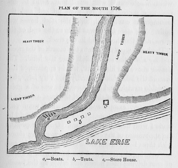
John Barr, Esq.,-Dear Sir: I received your letter of the 10th inst., requesting some information respecting the landing at Conneaut, of the first surveying company on the Reserve, and the appearance of the harbor, &c, I have no means of informing you except from frail memory. But it appears to me the view was so stamped in my mind, that if I was a painter or engraver, I could give a good view of it as it then appeared. I think the following is as good a representation as I can now give:
The lake at that time was very low, the beach was wide, and the lake calm. There was a wide space between the shore and the high bank, to the east of the mouth, which had resisted the force of the current and the waves, until there was considerable of a grove of midling sized timber grown on it. The south west wind had so long prevailed, that it had driven the creek back, and formed a wide sand bar down to the grove of timber, where it turned short into the lake. There was a considerable space left, between the creek and the high bank, which covered with small timber and bushes. On this space the tents were pitched and the encampment established, until the store house was built. The store house was built at the end of the grove, near the short bend in the creek. The boats were taken into the mouth of the creek, and lay along the south bank near the bend. The timber above the high bank, was in appearance like that of the lake shore generally, not very large, but tolerable straight and handsome. It was of a great variety, consisting of almost all the trees common in our country, except evergreens, which were very scarce on our lake shore. If an engraving should be made I wish there might be two. One to represent the appearance of the creek and surrounding shore, with three boats in the creek on the south side, and one entering the creek, near the bend, with a group of men driving pack horses and cattle up the beach, near the creek. On the other the boats side by side, on the south side of the creek, near the bend, and further back, and a little up stream, the tents, and in front of them, the agent and surveyors holding the council with the Indians. But I am not a painter or an engraver, and can't direct. I am well satisfied that the view which I herewith send is correct, except it may be not in a proper proportion, as to the length and breadth of the sand bar and beach. But I know they were then very wide. Yours, A. Atwater. INSTRUCTIONS OF THE DIRECTORS TO THEIR AGENT To Moses Cleaveland, Esq., of the county of Windham, and State of Connecticut, one of the Directors of the Connecticut Land Company, Greeting: We, the Board of Directors of said Connecticut Land Company, having appointed you to go on to said land, as Superintendent over the agents and men, sent on to survey and make locations on said land, to make, and enter into friendly negotiations with the natives who are on said land, or contiguous thereto, and may have any pretended claim to the same, and secure such friendly intercourse amongst them as will establish peace, quiet, and safety to the survey and settlement of said lands, not ceded by the natives under the authority of the United States. You are hereby, for the foregoing purposes, fully authorized and empowered to act, and transact all the above business, in as full and ample a manner as we ourselves could do, to make contracts in the foregoing matters in our behalf and stead; and make such drafts on our Treasury, as may be necessary to accomplish the foregoing object of your appointment. And all agents and men by us employed, and sent on to survey and settle said land, to be obedient to your orders and directions. And you are to be accountable for all monies by you received, conforming your conduct to such orders and directions as we may, from time to time, give you, and to do and act in all matters, according to your best skill and judgment, which may tend to the best interest, prosperity, and success of said Connecticut Land Company. Having more particularly for your guide the Articles of Association entered into and signed by the individuals of said Company. OLIVER PHELPS HENRY CHAMIPION } DIRECTORS ROGER NEWBERRY SAMUEL MATHER, JUN.
SURVEYING PARTY OF 1796.
General Moses Cleaveland, Superintendent. Augustus Porter, Principal Surveyor and Deputy Superintendent. Seth Pease, Astronomer and Surveyor. Amos Spafford, John Milton Holley, Richard M. Stoddard and Moses Warren, Surveyors. Joshua Stow, Commissary. Theodore Shepard, Physician. EMPLOYEES OF THE COMPANY. Joseph Tinker, Boatman. Joseph M'Intyre George Proudfoot, Francis Gray, Samuel Forbes, Amos Sawtel, Stephen Benton, Amos Barber, Samuel Hungerford, William B. Hall, Samuel Davenport, Asa Mason, Amzi Atwater. Michael Coffin, Elisha Ayres, Thomas Harris. Norman Wilcox, Timothy Dunham, George Gooding, Shadrach Benham, Samuel Agnew, Wareham Shepard, David Beard, John Briant. Titus V. Munson, Joseph Landon, Charles Parker, Ezekiel Morly, Nathaniel Doan, Luke Hanchet, James Halket, James Hamilton, Olney F. Rice, John Lock, Samuel Barnes, Stephen Burbank. Daniel Shulay, No. of Employees,- - 37 Elijah Gun, and Anna, his wife, came with the surveyors and took charge of Stow's castle at Conneaut. Job P. Stiles, and Tabitha Cumi, his wife, were left in charge of the company's stores at Cleveland. Nathan Chapman and Nathan Perry furnished the surveyors with fresh beef, and traded with the Indians. There were thirteen horses and some cattle, which completes the party of 1796.
For further reading: Encyclopedia of Cleveland History
|
||||||||||||||||||