|
FALL OF 1796 AND WINTER OF 1797.
What was accomplished in 1796 fell short of the expectations of all parties, particularly of the stockholders of the company. About fourteen thousand dollars had been expended upon the expedition. The field books of the surveyors show rapid work, frequently making eight, ten, and sometimes twelve miles a day. Warren appears to have been less energetic than the others, however, as he was continued in service the next year, the company must have been satisfied with him. When the season closed, there was a large tract in which no lines had been run. This was all that territory east of the Cuyahoga, west of the fourth meridian and south of the sixth parallel. The southern boundary of the Reserve, had not been continued west of the fourth Range, that is, only to the south-west corner of Berlin. Pease had run southerly, between ranges eight and nine, one township below the sixth parallel, to the north-west corner of Town five, Range eight, (Mantua,) and thence west to the Cuyahoga, on the north line of Northfield, which he reached on the 6th of September. None of the six townships intended for sale were allotted, except fractions number seven and eight in the twelfth Range, afterwards Cleveland and Newburg. None of the ten acre out-lots in Cleveland were surveyed. Around these are the one hundred are lots, numbering from 268 to 486, which, with the in and out lots of the city, cover fractional Towns seven and eight. Why the numbers of the one hundred acre lots were not commenced at number one, I have no means of explaining. The four townships making four hundred lots, intended for distribution, one to each share in the company, were not yet sub-divided. It is probable that all, or nearly all, of the township lines north of the sixth parallel were finished this season. One cause of delay in the surveys, was the time lost by all parties when they arrived at Chagrin river, and mistook if for the Cuyahoga. It was not always practicable to have provisions promptly delivered to the surveying parties, so that their work could go on without interruption. The axmen, chainmen, cooks, pack-horse men and boatmen, soon got over their first enthusiasm, which no doubt delayed their progress. After their experience in running the first four meridians, the romance of a line in the woods was very much dissipated. Every day was one of toil, and frequently discomfort. The woods, and particularly the swamps, were filled with ravenous mosquitoes, who were never idle, day or night. In rainy weather the bushes were wet, and in clear weather the heat was oppressive. They were not always sure of supper at night, nor of their drink of New England rum, which constituted an important part of their rations. Their well provided clothing began to show rents, from so much clambering over logs and through thickets. Their shoes gave out rapidly, as they were incessantly on foot, and were where no cobblers could be found to repair them. They had no special interest in the work, except their pay. It does not appear that their discontent arose to an open rupture with the surveyors, but was sufficient to hinder the progress of the work. The agent and his subordinates, were obliged to make promises of lands to such as proved to be faithful, which the proceedings of September 30th, sufficiently explain. Before they started homeward some of the party had selected lots in the capital city of New Connecticut. The allotment of the town and of the surrounding lots, was the work of all the parties. Porter states that he ran the outline of the tract to be compromised in the new town. Pease, Stoddard and Spafford had a hand in it, and Holley surveyed some of the one hundred acre lots. A rough map of the city was made during the survey, of a copy of which is here given. A few lots were sold probably on the terms proposed by Porter. Great expectations were formed of their projected settlement in Euclid, which, however, were not realized. FIRST MAP OR PLAT OF THE CITY OF CLEVELAND, OCT. 1, 1796
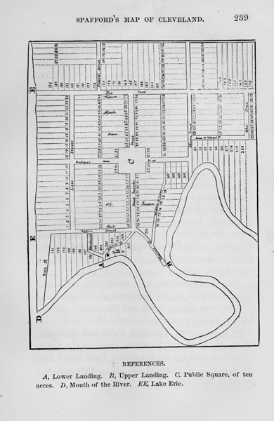
The original, of which this a copy, reduced by photography, was found among the papers of John Milton Holley, at Salisbury, Connecticut, in charge of his son, Governor Alexander H. Holley. It is endorsed in the hand writing of Amos Spafford: "Original plan of the town and village of Cleveland, Ohio, Oct. 1st, 1796." The sheet is formed, by pasting several sheets and parts of sheets, of foolscap together, evidently extemporized in the field. It was the first rough sketch, used by the surveyors before their return to the east. Superior street was at first named "Broad" street-a very appropriate title, as it then had no equal in width. Miami street had the name of "Deer" street-probably from the appearance there, of one of those animals during the survey. Maiden street, or lane, was ignored in the subsequent plat of Spafford, in 1801, and thus abandoned. On this map there is no extension of Superior street to the river, which was done by Spafford, under the name of Superior Lane.
The Public Square is here indicated by a blank space, like an enlargement of the streets crossing each other at that point. Ontario had at first the name of "Court Street," which is erased, and the present name is inserted. The letters A, B, C, D, and E, on the copy, are introduced by me, for the purpose of reference. On the face of the original, there are the numbers of the lots-two hundred and twenty in number; the streets, Superior, Water, Mandrake, Union, Vineyard, Bath, Lake, Erie, Federal, Maiden, Ontario, Huron, Ohio and Miami - fourteen in number, and the names of the parties who had selected lots. These were: Stoddard, lot 49, north-east corner of Water and Superior streets; Stiles, lot 53, north-east corner of Bank and Superior streets; Landon, lot 77, directly opposite, on the south side of Superior street; Baum, lot 65, sixteen rods east of the Public Square; Shepherd, lot 69, and Chapman, lot 72, all on the north side of the same street. "Pease's Hotel," as they styled the surveyors' cabin, is placed on the line between lots 202 and 203, between Union street and the river. North-west of it, about ten rods, on lots 201, their store house is laid down. Vineyard, Union and Mandrake streets, were laid out to secure access to the upper and lower landings on the river. Bath street provided a way of reaching the lake shore and the mouth of the river. After the return of the surveyors, regular field notes of the surveys of the city, were made out by Seth Pease, which are regarded as the official returns. With these notes is a map, styled on the face of it "Plan of the City of Cleveland, 1796," which is substantially the same as the one here given. The river bluffs are slightly differently, and the sand spit at the mouth is longer. There are the same number of streets with the same names, and the lots are alike on both; but the name of the city is spelled on the field plat without the letter "a," probably through inadvertence. In the papers and correspondence of those times, and until after the war of 1812, it is spelled both ways. General Cleaveland, from whom the city was named, always signs with the letter "a" in the first syllable. Several copies of the plat, were made on a scale about the same as the first draft, during the winter of 1796-97, for the use of the company, but it was never engraved. The first published map of the Reserve is that of Seth Pease, after his return in 1797. About the year 1816, soon after the organization of the village corporation, when some new streets were thought to be necessary, the authorized book of field notes, with its miniature plan, was brought here by James Root, Esq., brother to Ephram Root, the secretary of the company. This book remained until about the year 1856, since when, not being in official custody, it has disappeared. There is not now upon the Western Reserve a collection of the papers, maps, field books and proceedings of the company, from whom all our land titles are derived. A part of the Field Notes of Pease, Holley and Warren are in my possession. The survey of the city was commenced on the 16th of September, and completed about the 1st of October. Holley's descriptions of their departure and journey homeward as far a Canandaigua are full and interesting, and are given without curtailment. Monday, Oct. 17th, 1796-Finished surveying in New Connecticut; weather rainy. Tuesday, Oct. 18th-We left Cuyahoga at 3 o'clock 17 minutes, from home. We left at Cuyahoga Job Stiles and wife, and Joseph Landon, with provisions for the winter. Wm. B Hall, Titus V. Munson and Olney Rice engaged to take all the pack horses to Geneva. Day pleasant, and fair wind about south-east; rowed about seven and a half miles, and encamped for the night on the beach. There were fourteen men on board the boat, and never I presume, were fourteen men more anxious to pursue an object, than were to get forward. Names of men in the boat: Augustus Porter, James Hamilton James Hacket, Nathan Chapman, }Genesee Seth Pease, Ralph Bacon, } Stephen Benton, Milton Holley Richard Stoddard, George Proudfoot Joseph Tinker Charles Parker Wareham Shephard Amzi Atwater, Walnut creek, a pretty stream twenty or thirty links wide, empties into the lake about seven miles east of the Cuyahoga; not navigable for boats. The township of Cleaveland lies on the lake shore, eight miles, four chains, seventy links. About one-hundred and thirty chains east of the corner a stream, considerably larger that Walnut creek, empties into the lake. This is in the town purchased by the surveyors, and named (by Moses Warren, Esq.,) Euclid; in memory of the man who first made principles of geometry known. About ten miles from the Cuyahoga , a rock shore begins and continues to Chagrin river. This river is about fourteen rods wide at its mouth, and navigable for boats up three or four miles at all times, when there is no obstruction at the outlet, which however, is frequently the case, with this as well as most of the other rivers upon this lake, in consequence of the waves driving up a bank of sand. Wednesday morning, 3 o'clock-Clear and pleasant; moon shone bright, and we hoisted sail. About daybreak it began to thicken up in the west, and by sunrise the sky was hid from sight. Just before sunrise we passed the first settlement (except those made by ourselves) that is on the shore of the lake in New Connecticut. This is done by the Canandaiqua Association Company, under the direction of Major Wells and Mr. Wildair. After the sun rose the wind got into the north and north-east, and came on to blow so fresh that we were obliged to run ashore on the beach and pitch our tent, about a mile east of the Chagrin. Thursday, Oct. 20th, 1796-Started hale after six in the morning; no wind; against the ninth Range of towns. About nineteen miles by the lake shore from the Cuyahoga, a creek come in, which forms a large marsh lying a mile along shore, and on average one hundred rods wide; at twenty-seven miles come in Grand River. This stream is almost always a good harbor for boats, the outlet into the lake being about two or three rods wide and two or three rods wide and two or three feet deep. Just above the sand bar, made by the washing of the lake, the river is nearly twenty rods wide, and the depth sufficient for large vessels to anchor in. It continues this depth almost a mile, and is navigable for any boat four miles from the mouth, up to the Indian settlement, where are rapids which is now obstruct the passage, but with some expense might be made navigable for boats a great distance, I suppose forty of fifty miles at least. The general course is north, till it approaches within eight miles of the lake, when it runs twenty miles nearly due west before it empties itself. About thirty-six miles a burning spring in the lake, two or three rods from shore, which is very perceptible as you stand upon the beach, from its boiling motion. Mr. Porter told me that he, with General Cleaveland and Mr. Stow, had made a trial to know if it really was inflammable, which they found to be the case, although it was a very unfavorable time when they did it. The waves ran high, and the wind blew hard. They held a torch well lighted very close to the water, when there appeared a flame like that of spirits burning, but as it was so much mixed with other air, and the water so deep over it, (four feet) the flame would go out immediately. About 11 o'clock the wind began to blow from the north-east, and came so hard the we put ashore, and encamped near the spring at 1 o'clock, P.M. Friday, 21st.-Started about 2 o'clock; wind north-east, not strong; about 10 it lulled away, and we rowed to Conneaut; arrived about half after 12; took inventory of the articles left there, and about 4 o'clock in the morning, that is, on Saturday, the 22d, we hoisted sail for Presque Isle. We sailed and rowed prettily to the peninsula, unloaded, drew the boat across, and arrived at the garrison at 12 o'clock. Received a letter from my father of Sept. 16th, and one from Myron of the 15th, by Esquire Paine, of Onondaga county. This place is settling considerably fast, and, I think, must be a place of consequence, as it affords a good harbor vessels, has a good country around it, and is but fifteen miles by land from Le Beuf, which is on French creek, and about one hundred and fifty miles from Pittsburgh, to which place from Le Beuf, is good boating through French creek and the Allegheny river all the way. The journey is performed often in two days. Settlers from the north-western part of Pennsylvania take this route to get on the Presque Isle lands. The peninsula is abut seven miles in length, and from twelve rods to a mile wide. It is very little more than a bank of sand, although a great part of it is thickly timbered. The bay is about six miles in length and two miles wide. In the channel there is sufficient depth of water for ships to anchor, but they cannot get near shore. With some expense, a wharf can be made out to the channel, which is probably will be the case. Opposite the east end of the peninsula, on the main land, stands the fort. It has a commanding prospect and is agreeably situated, except a bad marsh between it and the lake, which in dry seasons is extremely unhealthy. Sunday, Oct. 23, '96-Left Presque Isle at 35 minutes past one o'clock in the morning; a land breeze from the south-west. The wind continued, and we rowed till about 1 o'clock, P.m., when it came so fast from the west, from where it had hauled that we sailed till 4 o 'clock ; the wind then lulled, and we plyed our oars again; arrived in Buffalo creek at half after 10 in the evening. We struck a fire, and were asleep in less than thirty minutes from the time of landing. Monday morning, Oct. 24th-Left Buffalo creek at 9 o'clock in the morning. We ran down the river to Chipeway landing, which is twenty miles distant, at half after 12 o'clock. We were so fortunate, as to get out boat and luggage carried across the portage immediately, by some teams that came to the shore just as we did. We rode in a wagon to Queenstown. Came across Capt. Davis at Major Ingersoll's inn. With him, Mr. Hunn, Mr. Butler and Major Pixley, we spent a sociable evening. Tuesday, Oct. 25th-We left Major Ingersoll's at half past 7, and came to Newark. Davis came with us. We breakfasted at Wilson's. Newark is a pleasant village, situated on the west shore of Niagara river, just as its entrance into Lake Ontario. It is laid out in city form, and there are many very pretty buildings. I think it will not be a place of so much business as Queenstown. Opposite Newark stands the ancient fort of Niagara, built by the French. It appears to have been a place of considerable strength, though many parts are now tumbling to ruin. We left Newark at half after 10 o'clock, A.M. ; wind north-east; about 1 o'clock the wind lulled, and we continued rowing till sundown, then encamped on the beach at the mouth of a creek, or marsh, called Key Harbor. The shore of the lake to this place is generally low and clayey. Just before we came to the harbor, a rocky shore commence. The opening, whence the marsh or creek come in, is about fifteen rods, and about twenty miles from the fort. Wednesday,. Oct. 26th-Started at 4 o'clock in morning; wind rather ahead. We rowed past Golden Harbor, the Eagle's Nest, and on to Oak Orchard; a creek of considerable size comes in here, supposed to be Tonawanda. From the appearance of the mouth, it never fills up with the sand, therefore is a good harbor for boats, (the others mentioned were filled) ; arrived here about 12 o'clock. This is about forty-five miles from the garrison at Niagara. Thursday, 27th-Wind north-east, in consequence of which we are obliged to lie still. I had the headache this day. Towards evening the wind lulled away, and at a quarter after 6 o'clock we left our encampment, and determined to row all night. It was extremely cold; the waves ran high, and the wind came on to blow considerably hard against us. However, we continued rowing, and about sunrise passed the Genesee river. Friday, 27th-At 7 o'clock and 45 minutes we entered the mouth of Gerundicut bay, and found a fire burning here. We breakfasted, and pursued our way at 9 o'clock. This bay is about four miles in length, and from one-half to three-quarters of a mile wide. A great part of it consists of flags, marsh, or a kind of mossy grass, coming close to the top of the water. Towards the head of the bay, the navigation is so difficult that we were obliged to strip, jump into the mud up to our waists, and haul the boat thirty rods to get into the channel. We pursued the river to the head of navigation, which is about eight miles as the river runs, which is very crooked. Porter, Pease, Stoddard, and myself stayed at Dunbar's that night, the others went on. Saturday, 29th-We breakfasted, and then set out on foot for Canandaigua, where we arrived at sunset. Lodged at Sanborn's JOHN MILTON HOLLEY Of him, Judge Amzi Atwater, in his sketches of the personal appearance of the surveyors says: "He was then a very young man, only about eighteen years of age, though he appeared to be older; tall, stout and handsomely built, with a fair and smiling face, and generally good appearance. He was a beautiful penman." Neither Holley or Porter returned to the survey in 1797. They eventually became brothers-in-law, Porter removing, at an early day, to the banks of the Niagara river. Holley settled in Salisbury, Connecticut, the old home of the Porters. He was a brother of Myron Holley, prominent in New York, as one of the Canal Commissioners of that State. John Milton spent his days at Salisbury, leaving a large and respected family. His son, Alexander H., once elected Governor of the State, still resides on the old homestead, near the famous Salisbury iron mine known as the "Ore Hill." MOSES CLEAVELAND. BY FREDERICK WADSWORTH, ESQ., OF AKRON "Mr. Cleaveland was a prominent and much respected citizen of Canterbury, Windham county, Connecticut ; born about the year 1755. He graduated at Yale College in 1777. In 1788, he purchased a portion of the interest of Samuel H. Parsons, in the Salt Spring tract, on the Meander creek. His profession was that a lawyer, practicing in his native town, where he died in 1806. He was a Brigadier General of militia, and a Representative in the Legislature. His daughter, Mrs. Frances Cleaveland Morgan, of Norwich, Connecticut, says the city of Cleveland was a decided pet with him so long as he lived. There were many papers and journals of her father, which have been scattered in the changes of the family. Mrs. Morgan still treasures the pipe which Paqua presented her father, at the conference on Conneaut creek." Mr. Atwater says General Cleaveland was "a short, thick set man, with a broad face, dark complexion and coarse features." In Judge Porter's letter of July, 1843, he states, that the General had furnished himself with an Indian dress, and being of a swarthy complexion, afforded an excellent likeness of an Indian Chief; and was honored thereafter by the party, by the name of "Paqua," the name of the chief of the tribe referred to." This resemblance to the aborigines, appears to have been patent to everybody. In Judge Spaulding's address before the Cuyahoga County Pioneer Society, in October, 1858, he refers to it as follows: "It is said of him, that some years after he left college, he attended and annual commencement at New Haven, where he met certain members of his own class, with whom he was examining the triennial catalogue, that had then just issued from the press. It is usual, in this catalogue, to print the names of such of the graduates as have studied theology, in italics. Gen. Cleaveland, in running his eye over the names of his classmates, chanced to find the name of one then present, who made no great pretensions to piety, printed in the form to denote a clergyman. Fond of humor and ready at a joke, he snatched a pen, and wrote against the name of his friend-"Settled at Mohegan;' which was then and is now, a small Indian settlement on the bank of the Thames, between Norwich and New London. The catalogue thus amended, was passed around the company, amid roars of laughter, until it came into the hands of the innocent subject of their mirth, when he, with easy facility and wit, retorted upon our hero, by writing against his name- 'Born at Mohegan." By reference to the list of original proprietors already given, it appears that he was an owner of $32.600 stock in the Land Company. After the business of 1796 was closed, it is not known that he afterwards visited the Reserve. Of his Indian name-sake, Paqua, or "Pawquaw," Mr. Atwater says: "He was not a large Indian, but straight and handsomely built, with a fair and pleasant countenance, lighter than most Indians." JOB P. STILES. Job P. Stiles and his wife had a cabin built for them on the hill, before the surveyors left. Richard Landon, one of the surveying party, was left to spend the winter with them, upon this dreary spot. From some cause not yet explained, he soon after abandoned the place, and Edward Paine took up his residence with the Stiles family. During the winter a child is reputed to have been born in the cabin, which had only squaws for a nurse. The Indians who were quartered here at that time, constituting by far the most numerous part of its population, treated these lonely settlers with great kindness. Paine was a trader with the Indians during the winter of 1796-'97, who afterwards became a prominent citizen of Geauga county. Stiles left here in 1800, and arrived to a good old age, dying in Leicester, Addison county, Vermont, about the year 1850. The courageous Mrs. Stiles lived to a still later period, but when her death occurred I am not informed. Pease's Journal of the return from New Connecticut, agrees closely with Holley's. In getting out of the river, on the 18th of October, he says: "It was much obstructed by a sand bar, occasioned by a violent gale from the northward the day before. It was with some difficulty we reached the lake. "We put ashore where two small runs empty into the lake, in the eastern part of Euclid. I walked a short distance to a settlement begun by the Canandaigua Company, Major Wells Agent, and received some provisions that had been lent them by us." This is the settlement referred to by Holley, whose history is not yet developed. Mr. Pease met with many difficulties and discomforts, on the journey from Canandaigua to Suffield. Friday, November 8th.-"Eight miles beyond Cayuga Lake, found difficulty in getting provisions on the road, the water being so low the mills could not grind." Saturday, Nov. 9th-"A little beyond the Onondaga river, a gentleman let me ride his horse, although he was bare back." Sunday, Nov .16th- "Got home about 2 o'clock in the morning." His "home" was at Suffield, on the banks of the Connecticut river, above Hartford. After the surveyors returned in the fall of 1796, a meeting was called on the 17th of January, 1797, at which the Directors and Trustees, were required to urge the Legislature to erect a county comprising all the Western Reserve. A committee was appointed to enquire into the causes of the "very great expense of the Company during the first year, the causes which have prevented the completion of the surveys; and why the surveyors and agents have not made their reports. A tax, or assessment, of five dollars per share, was also ordered, the number of shares being four hundred. A committee of Partition was appointed consisting of Daniel Holbrook, Moses Warren, Jr., Seth Pease and Amos Spafford. Another committee was raised to inquire generally into the conduct of the directors. At a subsequent meeting, on the 22d of February, 1797, this committee made their report, thoroughly white-washing the directors, and overwhelming the dissatisfied stockholders. They also "voted that Moses Cleaveland's contract with Joseph Brant, Esq., in behalf of the Mohawks, of Grand river, Canada, be ratified." By this time the distressing fact became known, that the "Excess Company" had no land whatever. Augustus Porter, who had made a traverse of the lake shore, from the Pennsylvania line to Sandusky bay, ascertained that it bore much more to the south, than the old maps represented. Upon calculating the contents of the tract, including the Fire lands, he discovered that the Land Company had less than three million of acres, the quantity for which they had paid.
For further reading: Encyclopedia of Cleveland History
|
||